|
Revised 7-19-18 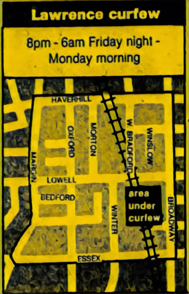 Above: Leaflet showing area under police curfew after the second night of rioting The riot started the night of August 8, 1984 near the intersection of Oxford Street and Haverhill Street, and flared up again the next night. News accounts describe the area of the riot as "Lower Tower Hill", however, it really occurred right below Tower Hill in the flatlands that end at the aptly-named Margin Street. The unrest spread not up the hill (which would be to the left on the map) but along the base of the hill, over to the Merrimack Courts housing projects on Essex Street, and then to the Hancock projects beyond. Below: Coverage of the riots in the Boston Herald 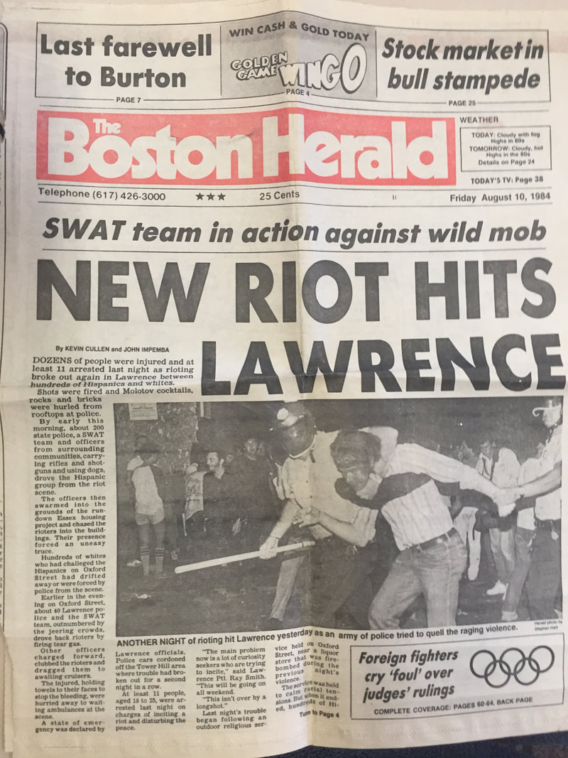 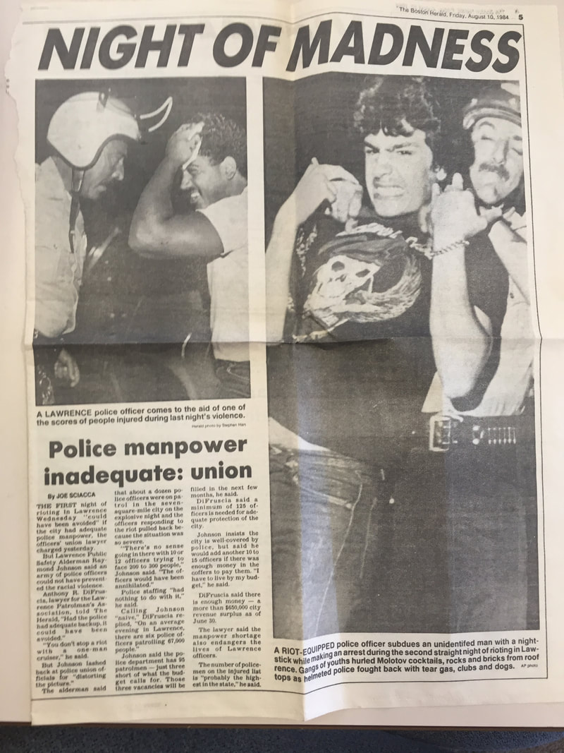 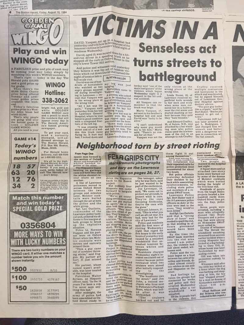 In my view, the riot was not a very big disturbance, albeit one that local police could not get under control on the first night. It happened less than half a mile from my house with no immediate impact beyond a narrow zone running between Broadway and Margin Street along the base of Tower Hill, across an area of probably less than ten acres. I have suggested that it was more like a large-scale rumble, and not a "riot" in the same sense as the gigantic Detroit riots or Watts Riots which ranged over hundreds of acres destroying a lot of those cities. Even locally, compare the 1964 Hampton Beach riot, which involved up to 10,000 youth battling state police from New Hampshire and Maine and many neighboring towns. This riot was more of a local affair. Sometimes the rioters even cooperated, for example when they were dividing the loot: “At 11:00 PM rioters broke into Pettoruto’s liquor store. The Eagle-Tribune reported that at first the two groups [presumably whites and hispanics] fought over the liquor, but then they cooperated to divided it up and share it, after which a ‘lull followed with a lot of public drinking.” This is from Llana Barber's book Latino City, mentioned below. The author notes dryly, “This odd reprieve could not have been long lived, because by 12:15 AM, the liquor store was on fire.” A theory about the riot: I have a theory that the riot was directly related to the 1982 "desegregation" of the two nearby schools, which destabilized the geographic social order by giving kids from the "wrong" side of an invisible line a newfound right to pass all the way to the top of the hill, which at that time was another world. The two schools involved were the Hennessy School down on Hancock Street next to the projects; and the Bruce School (my school from kindergarten through 8th grade), at the top of the hill. School desegregation upset longstanding geographic hierarchies of the area, which were based as much on social class as ethnicity or race. When I was a kid, in the single family homes and duplexes near the Reservoir or up the hill from the Bruce, families were "middle class". The parents of about half my neighbors were college educated, many of them teachers or working for the city; and the other half owned small businesses, such as plate glass or oil delivery, or sold insurance, or did other respectable, responsible things. Nearly everyone owned their home. Going further down the hill, the homes were multifamily and the youth were often rougher. Nobody went to college. Almost everyone rented. Dads seemed to be in motorcycle gangs, fixed cars, worked as roofers. Down at the bottom, where the slope ended and the terrain flattened out, were fresh-off-the-boat immigrants...most recently from the Dominican as well as Puerto Ricans who had started arriving in the early 1970s. After the 1982 desegregation, the population of the Bruce School changed dramatically. In a short while, many of my friends switched schools. The nearby parochial school on Ames Street, St. Augustine's, had a couple banner years of attendance (it is now closed). The Bruce school was to be flooded with kids from down the hill. To entice some middle class families to stay, a "Magnet School" was created in a neighboring building, a former synagogue that had relocated to Andover when the congregation all moved away in the 1970s and early 1980s. (The J.C.C. fifty yards from my house limped on, without members, before finally closing in 1990.) Despite the magnet school and the availability of St. Augustine's parochial school, the neighborhood also changed character within a couple years. The population from down the hill came up the hill, as the previous population moved out, so that the line that used to be at Margin Street moved up the hill a few blocks every year. Eventually, everything had changed, all the way over the top of Tower Hill and down the backside of the hill to Methuen. In 1985, the Hispanic population of Lawrence was 16%; it is presently around 80%, in a city that has 15,000 more residents than it did back then. I'm sure my former neighborhood is also 80% Hispanic overall. My parents still live there, up by the Reservoir. Professor Llana Barber extensively discusses the Riot in her book Latino City (2017), giving a synopsis of how Lawrence became a Latino city through and through. My review of her book is here. The poorly executed 1982 school desegregation that conflated race and ethnicity with social class, and then the riot, simple hastened a trend that would have happened anyway: Lawrence becoming a majority-minority city. In many ways, Lawrence is now a Hispanic Shangri-La, a place where people of a shared culture can live among their own, while still participating in the overall economic benefits of the Greater Boston area. The people who have moved out of Lawrence since the 1980s often look back with nostalgia on the way things used to be, and some of them unfairly scapegoat the new immigrants of Lawrence for what they see as negative change. However, I'm sure that in 30 years, when the current residents of Lawrence and their kids have also moved on, to "better" areas, they too will look back fondly on the old neighborhood in Lawrence where everyone spoke their language, listened to their music, and ate their cuisine. Below: AP photo of riot police in Lawrence. Erika Market was on the corner of Oxford Street and Lowell Street. 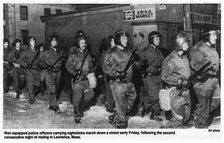
5 Comments
I have not been able to determine where any Irish ancestors lived before they emigrated to the United States at the time of the Potato Famine. The most I have been able to find is ports of disembarkation via ship records.
A huge drawback in doing research is that the Irish census records for the years 1821 to 1851 were almost entirely destroyed in the fire which consumed the Public Record Office of Ireland in 1922 after bombardment in the Irish civil war. The 1821 census was the first full census of Ireland. Nationwide civil registration of births and deaths started in 1864, and is therefore also not helpful. “Before the start of civil registration for all in 1864, virtually the only direct sources of family information for the vast majority of the population are the local parish records. However, because of the disadvantages suffered by the Catholic Church from the sixteenth to the nineteenth centuries, record-keeping was understandably difficult…”[1] “In the poorest and most densely populated rural parishes of the West and North, those which saw most emigration [most ancestors named Driscoll, McDonnell as well as McCarthy would have likely come from the far southwest], the parish registers very often do not start until the mid or late nineteenth century. However, the majority of Catholic registers begin in the first decades of the nineteenth century, and even in poor areas, records were often kept from an earlier date.” Unfortunately, many Catholic parish records are not online. “The only way to be sure of the extent of surviving records is to check the individual parish. The National Library catalogue, available at the counter in the main reading room [of the Irish National Records Office], is the only printed, comprehensive, country-wide account of Catholic registers…” That said, an increasing number of Catholic church records have been put on line starting in 2011, although not everything has been indexed. www.irishgenealogy.ie/en/church-records/help/searching-by-person Even if I find the time someday to investigate Catholic parish records in detail, deciphering them might not be easy. “Baptisms and marriages are recorded in either Latin or English, never in Irish. Generally, parishes in the more prosperous areas, where English was more common, tended to use English, while in Irish-speaking parishes Latin was used.” Assuming most of my ancestors came from rural Cork, Irish (or Gaelic) would still have been used in some pockets. The fact that names are in Latin presents research problems. Here is a partial interpretive key showing how English names were translated into Latin. (Keeping in mind that most English names were Anglicizations of traditional Gaelic names!): Carolus = Charles Demetrius = Jeremiah/Jerome/Dermot Gulielmus =William (I have not seen any William among my Irish ancestors) Eugenius = Owen or Eugene Jacobus =James Ioannes or Joannes = John; and so on. Dispensations for marriages between cousins were often given. “These were necessary when the two people marrying were related, consanguinati, and the relationship was given in terms of degrees, with siblings first degree, first cousins second degree, and second cousins third degree, Thus a couple recorded as consanguinati in tertio grado are second cousins, information which can be of value in disentangling earlier generations.” A typical Latin entry in its full form might read: Baptisavi Johannem, filium legitimum Michaeli Sheehan et Mariae Sullivan de Lisquill. Sponsoribus, Danielus Quirk, Johanna Donoghue. Much more often the entry is abbreviated to: Bapt. Johannem, f.l. Michaeli Sheehan et Mariae Sullivan, Lisquill, Sp: Daniel Quirk, Johanna Donoghue. Translated, this is simply "I baptised John, legitimate son of Michael Sheehan and Mary Sullivan of Lisquill, with godparents Daniel Quirk and Johanna Donoghue". A typical Latin entry for a marriage would read: In matrimonium coniunxi Danielum McCarthy et Brigidam Kelliher, de Ballyboher. Testimonii: Cornelius Buckley, Margarita Hennessy. Abbreviated, the entry reads: Mat. con. Danielum McCarthy et Brigidam Kelliher, Ballyboher. Test. Cornelius Buckley, Margarita Hennessy. Meaning, simply, "I joined Daniel McCarthy and Brigid Kelliher, of Ballyboher, in matrimony; witnesses, Cornelius Buckley, Margaret Hennessy." The fact that Irish children were typically named after specific relatives in accordance with birth order, most families have a limited set of first names, making research more difficult because many people have the same first and last name! Irish naming conventions - or why everyone in an extended family seems to have the same five or six names! The common practice of naming children after relatives according to a set formula meant that families often had a constellation of a dozen or fewer first names for girls and a dozen or fewer first names for girls across many generations, especially if cousins were marrying each other. The first born daughter is named after the maternal grandmother (mother’s mother); first born son is named after the paternal grandfather (father’s father); the second daughter is named after the paternal grandmother (father’s mother); the second son is named after the maternal grandfather (mother’s father); the third daughter is named after the mother; the third son is named after the father; the fourth daughter is named after her mother’s oldest sister (Aunt), the fourth son is named after his father’s oldest brother, etc. Among my Driscoll ancestors (my mother's mother's maiden name), the main names include John, Patrick and Jeremiah for boys, and Mary and Ellen for girls. Jeremiah somehow had become the Anglicization of Irish name Diarmaid, now more commonly anglicized as Dermot. [1] http://www.irishtimes.com/ancestor/browse/records/church/catholic/#Church. All text in quotes in this blog entry comes from this source. My research on Native American interactions with early English settlers of Massachusetts and New England led me to the writings of one Thomas Morton, who in 1638 wrote detailed accounts of the Pennacook and other bands of Indians. (Note - I tend to call the colonists “English” and the natives “Indians” because all the writings from the colonial period use these terms.)
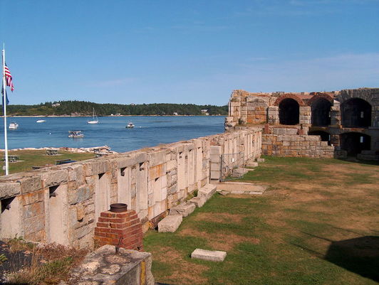
It turns out that, in 1626, before the Puritans were establishing Boston, Thomas Morton and some friends established a colony called Merrymount (as in, a hill for merriment), a.k.a. Wallaston. The name lives on as a subway stop on the Red Line in Quincy, Mass., site of the small colony, but it otherwise seems to have been forgotten. From what I could gather, it was sort of the anti-Puritan colony, full of drunken revelry, hooking up with native females, and a lot of other activity that no doubt drove the puritans mad. Here are some of my quick notes. Some of this might be cut and pasted from copyrighted material so I may need to edit this. Morton disdained the Pilgrims at Plymouth, who he called ‘those Moles.’ He complained they ‘keep ‘much ado about the tithe of mint and cumin, troubling their brains more than reason would require about things that are indifferent.’ He called the first governor of Massachusetts, John Endicott, “that great swelling fellow, Captain Littleworth,” and called the short Myles Standish, military leader of the Plymouth colony, ‘Captain Shrimpe.’ On May 1, 1627, Merrymount decided to throw a party in the manner of Merrie Olde England. Morton hoped it would attract some Indian brides for his bachelor followers. Thus, he violated a cardinal concept of English settlement of New England: endogamy, or marriage solely within the group. In contrast to French Quebec and Acadia, where European-native marriages were tolerated (possibly because settlement was largely by men), they were a big no-no in New England (possibly because settlement was by supposed to be by families and entire villages that came over from England together). Morton was arrested on Sept 30, 1629 and was sent back to England by the Puritan authorities. The account of his transgressions said, "The inhabitants of Merrymount ... did devise amongst themselves to have ... Revels, and merriment after the old English custom ... & therefore brewed a barrell of excellent beer, & provided a case of bottles to be spent, with other good cheer, for all comers of that day. And upon Mayday they brought the Maypole to the place appointed, with drums, guns, pistols, and other fitting instruments, for that purpose; and there erected it with the help of Savages, that came thither of purpose to see the manner of our Revels. A goodly pine tree of 80 foot long, was reared up, with a pair of buckshorns nailed on, somewhat near unto the top of it; where it stood as a fair sea mark for directions, how to find out the way to mine Host of Ma-re Mount." Gov. William Bradford was horrified by the ‘beastly practices of ye mad Bacchanalians.’ After a second Maypole party the next year, Myles Standish led a party of armed men to Merrymount, seized Morton and put him in chains. Not a shot was fired. According to Morton, the Merrymount inhabitants didn’t want bloodshed. According to Bradford, they were too drunk to resist. Morton wrote a guidebook of sorts in 1638 while back in London, on the culture of the New England Indians. He supposedly used the money from the sale of the book to pursue a lawsuit against the Massachusetts Bay Colony. I don’t know what came of that lawsuit. In his book, he compares the native Americans to the Irish in their primitiveness. “The Natives of New England are accustomed to build themselves houses much like the wild Irish; they gather poles in the woods and put the great end of them in the ground, placing them in form of a circle or circumference, and, bending the tops of them in form of an arch, they bind them together with the bark of walnut trees, which is wondrous tough, so that they make the same round on the top for the smoke of their fire to ascend and pass through; these they cover with mats.” He also wrote, “when they have their apparel on they look like Irish”. Ireland was of course England’s first colony. 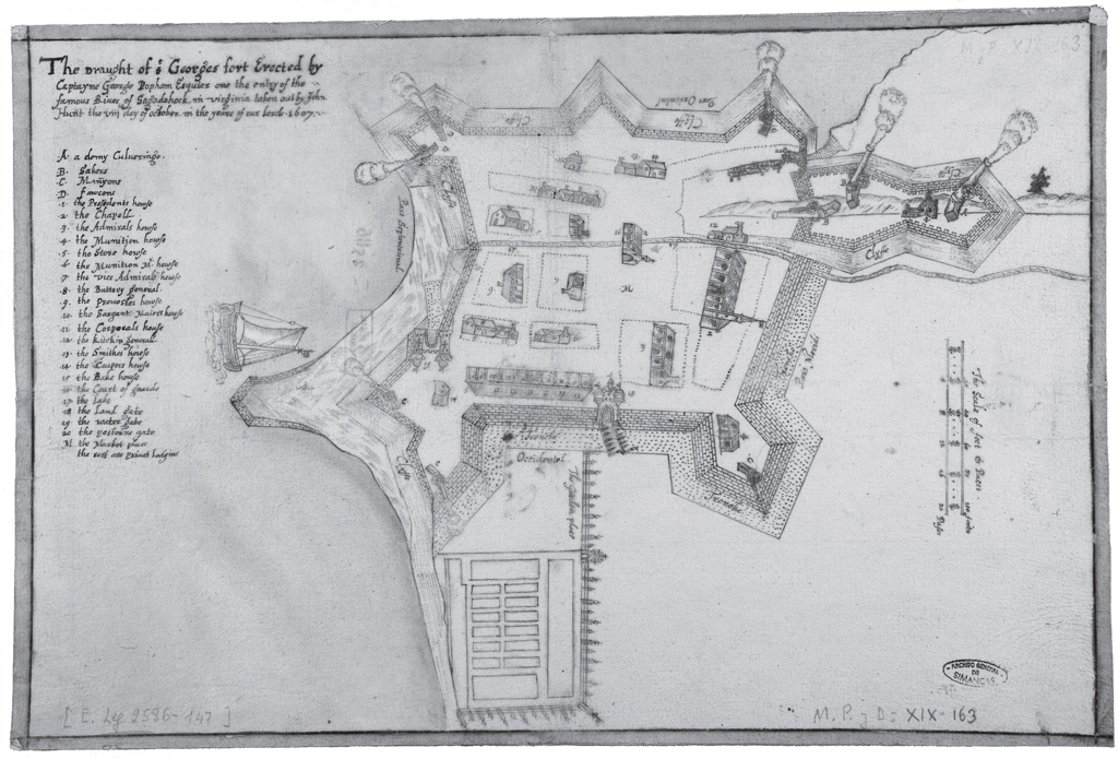 The "Hunt Map" showing Fort St. George, the fortification at the short-lived Popham Colony Everyone knows the story of the Plymouth Colony of 1620, revisited every Thanksgiving, and many people have at least some notion of the Puritan settlement of Massachusetts Bay Colony. However the English colonization of New England was sometimes a messy affair full of false starts and paper claims, especially to the north of Massachusetts Bay. The story of New Hampshire (which managed to break away from Massachusetts for good in 1741) and Maine (which took until 1820) can be covered in other blog entries. Here are some notes on the short-lived Popham Colony of 1607. Until this year I had never heard of it. The Popham Colony—also known as the Sagadahoc Colony—was a short-lived English colonial settlement in North America that was founded in 1607 and located in the present-day town of Phippsburg, Maine, near the mouth of the Kennebec River by the proprietary Virginia Company of Plymouth. It was abandoned after a year despite low mortality. The first ship built by the English in the New World was completed during the year of the Popham Colony and was sailed back across the Atlantic Ocean to England. The pinnace, named Virginia of Sagadahoc, was apparently quite seaworthy, and crossed the Atlantic again successfully in 1609 as part of Sir Christopher Newport's nine vessel Third Supply mission to Jamestown. Postage Stamp from 1957 Commemorating the "Virginia of Sagadahock" 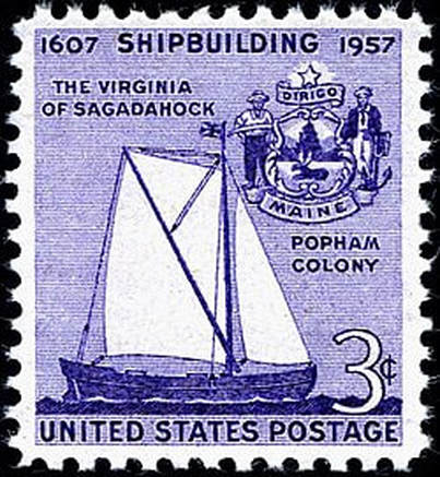 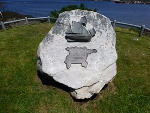 A contemporary monument to the ship Virginia of Sanghedoc at the Popham site On May 31st, 1607, the ships Gift of God and Mary and John departed for the intended Popham Colony carrying some 120 colonists - a slightly larger group than had travelled from London to Jamestown. Unlike that rival expedition, the Plymouth group took just nine council members and half-a-dozen other notable gentlemen, with the majority being mainly soldiers, craftsmen, farmers and traders, their objective to reach the coast of 'North Virginia' at a latitude of about 43 degrees north. The Gift of God arrived at the mouth of the Sagadahoc River (now the Kennebec in Maine) on August 13th, and Mary and John followed three days later. • The exact site of Popham Colony was unknown in modern times until it was discovered in 1994 and excavated by archaeologists for next ten years. It was within a stone's throw of present day Fort Popham, built during the U.S. Civil War to protect the mouth of the Kennebeck. • Discovery was aided by the picture-plan of Fort St. George that was drawn on site by one of the colonists. It is unique since it is the only detailed drawing that exists for an initial English settlement anywhere in the Americas. Fortified with a ditch and rampart, the enclosure contained a storehouse, chapel, guardhouse, and other public buildings, as well as residences for the colonists. The fort was defended by nine guns that range in size from demi-culverin to falcon. The boat built by the colonists, the pinnace Virginia, floats offshore although it could not have been completed by the date of the map. • The Hunt map had been lost to history until it surfaced in a royal archive in Simancas, Spain in 1888. It ended up there via a 1608 dispatch to the Spanish king from Don Pedro de Zuniga the Spanish ambassador in London. The dispatch also contained a sketch of the English colony at Jamestown also founded in 1607. How he got his hands on hunt’s map is unclear. • The 1607 founding of the Popham Colony (also called Fort George) was the second attempt by the Plymouth England branch of the Virginia Company which had been given a charter to coastal North America above the 38th parallel, roughly modern northern Virginia. The more famous Virginia Company of London was given a charter south of the 41st parallel (roughly modern NYC). Note the geographic overlap. • The Richard, a ship sent by the Plymouth Company in August 1606 under the command of Captain Henry Challons, never reached its intended destination in what is now the state of Maine, being intercepted and captured by Spanish forces near Florida in November 1606. • The Popham Colony was abandoned because leader George Popham died (his rich uncle had financed the expedition), and second-in-command Robert Gilbert learned he had inherited a title and landholdings back in England. Below: Map Showing the lands granted to the two Virginia Companies, the more famous Virginia Company of London (founders of Jamestown) and the Virginia Company of Plymouth (founders of the unsuccessful Popham Colony - later, they took jurisdiction over the Separatist colony that incidentally landed in their claim, which was named Plymouth). Note the overlapping area between the two companies. SOURCE: www.mainestory.info/maine-stories/popham-colony.html (Pat Higgins) 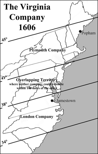 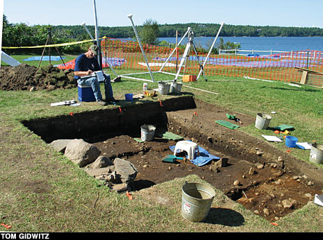
 This is a book that I’ve basically been looking for, for years. Although it has very interesting chapters, state by state, on the settlement of the American Midwest and West by Yankees from New England, I mainly like it for its poignant description of the depopulation of upland New England, which is relevant to my genealogical background (see “About” page of this blog).
This topic is also very poignantly covered by Robert Frost, claimed by my hometown of Lawrence because he went to high school there. See, for example, his poetry collection “North of Boston”. The dialect spoken by Frost, which can be heard on recordings of him, to me really captures the North-of-Bostonregional dialect, now nearly lost. A topic to be explored in another blog entry... Here are some good quotes from Yankee Exodus. “My interest in migration from New England began some forty years ago, when I first became conscious of the many deserted hill farms in my native Vermont, and in New Hampshire where I also lived. The old cellar holes, the orchards being slowly throttled by encroaching forest, moved me deeply. I had a fairly good idea of what had gone into the making of those hill farms and homes; and the fact that they had been abandoned, after a century or more, seemed to me a great tragedy. It still does.” “In good time I myself joined the exodus, and though I visit there almost annually, for thirty years and more I have lived outside New England. Everywhere I went, I met native Yankees or the descendants of Yankees; and came to the conclusion, in no way original, that Yankees must have had a good deal with the civilizing the United States lying west of Lake Champlain and the Berkshires; and, of more importance, had perhaps exerted an influence in those foreign parts immensely greater than was commonly believed and also all out of proportion to their numbers.” These quotes were from the book’s Foreword. The actual start of the book, chapter 1 (called “Melancholy on a Hill”) is also amazing: “The Hill, my great-grandfather had said, produces the best maple honey in Vermont and the biggest supply of material for stone fences you could imagine. He always had plenty of one, and far too much of the other. When he went there, a little after the end of the Revolution, with the truly appalling idea of clearing a farm in the forest, the entire hill was enveloped with the immense hush of an illimitable wilderness. Now, a century and a half later, the silence is returning, along wit the wilderness that is marching from the edges of the old fields and pastures straight across and up and down, swallowing miles of stone fences, tearing pastures straight across and up and down, swallowing the miles of stone fences…” The first chapter captures exactly the tenor and detail I’ve been looking for to describe life in, and then the slow depopulatingfrom, upland new England. “They all came to call on their fellow Vermonters – the Dorreliates, the Perfectionists, the Christians (from near-by Lyndon); and so, too, the Anti-masons, the antinicotine forces, the Temperance shouters; the hydro therapists, the anticalomelmen, the hosts of assorted Sabbatarians, the sellers of lightning rods. So, also, the Abolitionists, the Friends of Liberia, the vegetarians, the Grahamites, the Thomsonians, the homeopaths.” “And when the times became dreadfully hard, and Yankees in their desperation started to make gadgets and such for sale to other Yankees – because they had no other market – this house resounded to the heralds of tin calf weaners and Seth Thomas’s clocks, of mouth-organs and parent water-watches, of soapstone stoves and Thayer’s Slippery Elm Lozenges. Once, at least, came a persuasive man who sold mulberry bushes, complete with worms, on which, he vowed, any hill farmer could make a fortune from silk.” |
|
|||||||||
 RSS Feed