Jewish Lawrence observed: My grandfather's retirement in 1949 to the top of Tower Hill in Lawrence12/9/2017 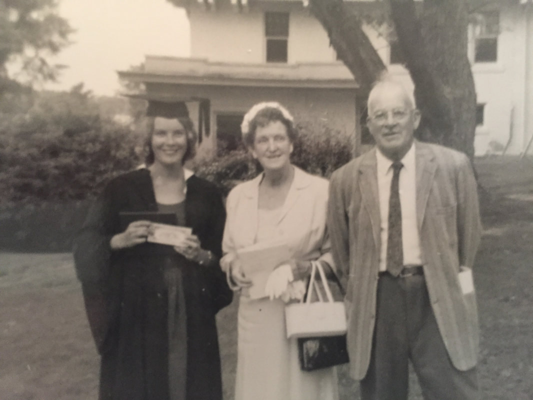 Above: My grandparents Mary (Driscoll) McDonnell and Joseph McDonnell at my mother's college graduation, 1960
I'm interested in the history of my grandfather's relationship to his Jewish neighbors. Specifically I wonder how he ended up building his retirement home in 1949 in the then-predominantly Jewish neighborhood of Tower Hill in Lawrence Massachusetts, moving from his prior home in the Irish section of South Lawrence, along Kingston Street by St. Patrick's Church If I consider this move, along with other indicators – for example, that every winter he and his wife would travel to Fort Lauderdale Florida for their annual vacation, or that he was a smalltime real estate developer, or that he may have had a tendency to obfuscate his Irish Catholic background (he told mill overseers his surname was McDonald, which was Scottish, and which allowed him a better job) – the pieces of a puzzle perhaps begin to emerge. Consider Lawrence in the 1940s. When he began building his house in 1949 at the age of 60, the city was still regional center, although on a terminal decline. He had worked for four decades as proprietor of hotels and rooming houses and was entering retirement with his wife. Summers were spent running the properties at a New Hampshire resort for the workers, Hampton Beach, and winters were spent in Fort Lauderdale, Florida. Tower Hill in Lawrence, the location of his new home, had in the postwar years become the preeminent Jewish neighborhood of greater Lawrence. This period, especially the early 1950s, was marked by the construction of two synagogues on the upper part of Lowell Street and a Jewish community center (JCC) within 100 yards of the site of his new house. (One of them, Temple Emanuel, moved to Andover in 1979 and its buildings became the Bruce School annex magnet school mentioned in my blog post on the 1984 Lawrence riot.) The local public school, the Bruce school, which I attended for nine years starting in 1976, apparently allowed days off for Jewish holidays and was at one point in the early 1960s over half Jewish. Question: did my grandfather choose the neighborhood because he perceived it as an appropriate home for a successful businessman, much like the other residents of this neighborhood; or did he have specific personal links to some of the Jewish residents? And, tangentially, why did he winter in Fort Lauderdale? He had been going there for years, and in 1926 purchased a significant parcel of land which they later sold in the 1950s. I'm not sure it's possible to gather any more information. From talking to my mother, I get the impression that his friends were mostly related to his wife, my grandmother Mary Driscoll, a sociable and gregarious woman who had a penchant for Cadillacs and fur coats. Yet I can also imagine a separate sphere of business colleagues, untethered from being "couples friends" – men who developed apartment buildings and commercial real estate, or who had businesses focused on hospitality - who might have influenced his choice of where to retire. The final puzzle piece is his choice of developing property in Hampton Beach, N.H. This town was restricted, and covenants running with the land routinely prohibited sales of property to Jews, unlike the practices in the neighboring seaside resort areas of Salisbury, Mass. For this reason alone, I have concluded that any decisions of my grandfather to retire to Tower Hill in Lawrence, or to winter in Fort Lauderdale, had nothing to do with whether they were Jewish areas. Nevertheless, I will cotinue to investigate this topic. ULDATE MARCH 7, 2018: I have since learned that, whereas Miami Beach was considered fairly Jewish, Fort Lauderdale was “waspy”. Thiis plus the restricted nature of Hampton Beach probably kills my thesis that my grandfather moved to Tower Hill because he had Jewish business connections.
0 Comments
(A long read)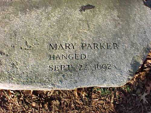 Above: Monument to Mary Ayer Parker, Salem, Mass. Source: Find-A-Grave Background By the end of 1678, the first major episode of violence between natives and English colonists was over. Nearly 10% of the English population was killed in this King Philips War, but it was even more destructive for the natives. The eradication of the Narragansett and Wampanoag tribes and the weakening of the other tribes in the settled parts of New England did not mean the threat of Indian invasion disappeared, however. Instead, for the towns along the northwestern frontier of English settlement of North America – places like Haverhill and Andover – the threat actually grew. This is because the remaining natives became proxies in the rivalry between global empires, France and England. Some Indian groups had historically plundered the coastal tribes of New England...for example, the Mohawks from west of the Hudson, and the Ohio Valley-based Iroquois. Members of both tribes became paid mercenaries along the English-French frontier, in what is now Maine, New Hampshire and Vermont. Other tribes were fighting back against the encroaching devastation of their native lands. The Abenaki entered into a formal political alliance with the imperial government of France, seeking an established place in “Arcadia”, which was the colony of New France that extended from the present Canadian maritime provinces all the way down to the Kennebec River. Members of all three tribes became a threat to settlements of the puritan English frontier. Disruption to Lower Merrimack Valley and Northern Essex Region The first imperial proxy war became known as King William’s war, named after the distant English king, William of Orange, a newcomer from Holland who along with his wife Mary had inherited the English throne after the demise of the house of Stuart. He led a coalition of kingdoms against France. The opening volley in our part of the world was an attack directed by the governor of the Province of New England, who in 1688 organized a militia raid on the de facto French military leader of Arcadia, Jean-Vincent d'Abbadie de Saint-Castin, at what is now Castine, Maine, the southern-most point of French settlement. Saint-Castin was married to a Penobscot Indian princess and commanded mainly an army of Indians, aided by Jesuit priest-soldiers. This attack on Saint-Castine triggered war in the region. Abenakis and their French allies retaliated by targeting English settlements far down the Maine coast. They attacked Kennebunk in September of 1688; Salmon Falls (now Berwick) Maine in March 1690 (in which about 90 English villagers were killed or imprisoned for ransom); Wells in June 1691; and York in January 1692 (the so-called Candlemas Massacre in which 300 English villagers were killed or imprisoned for ransom). As a result of these devastating raids, dozens of English families fled southward into the relative safety of the Merrimack Valley and Essex County, past the warring tribulations of Kangamagus, last of the great Pennacook chiefs, near Dover. Below: Memorial to the victims of the Candelmas Massacre, January 24, 1692, York, Maine 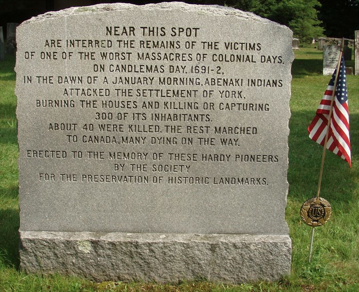 The refugees mainly swarmed Salem -- divided into Salem Town, now Salem, and Salem Village, now Danvers-- Ipswich, Haverhill and Andover. This influx of refugees strained resources and is thought to have contributed to the social unrest in these areas that caused “witch fever” to take hold. Although the hangings and other executions were centered in Salem Town, the most accusations of witchcraft apparently occurred in Andover, on the frontier twenty miles inland on the banks of the Merrimack. Andover had already suffered one Indian raid in August 1689, when the Peters house was burned and two persons were killed, so paranoia and apprehension likely ran high. Andover in the late Seventeenth Century The frontier region of northern Essex County in the late 1680s and early 1690s barely resembled the wilderness encountered fifty years earlier. Land had been allocated and cleared, and native trails became roads. Tight clusters of wood frame houses surrounded a parish meetinghouse; when the population grew too numerous, residents built houses far away from the meetinghouse. The road to Boston (present-day Route 28) and the road to Salem Town (present day Route 114) were bustling with trade at times, as grain, produce and timber made their way to market; and smoked fish, molasses from the rum trade, and finished goods made from England their way back to the hinterlands. Small boats could make their way up the Merrimack to Haverhill, site of the first falls, called Pentucket by the natives. Grist mills and lumber mills lined the streams, and tanneries and cottage industries provided basic clothing material, with the rest - such as cotton – shipped in through Boston and Newburyport. Despite the prosperity and relative stability of towns like Andover and Haverhill, the threat of Indian raids caused a general tone of apprehension. “The Indians were enemies very much dreaded. They concealed themselves and lay in ambush, and waited long and patiently, for an opportunity to surprise their prey. They never made their attacks openly, nor fought in the open field. The time of assault was often just before dawn of day, when they could strike the blow without resistance, and could cause the greatest panic. The inhabitants did not feel safe in their fields, and were liable to be shot down while at their labor. They frequently carried their firearms with them to their work. They also carried their guns when they assembled for worship on the Sabbath, and were exposed to be way laid in going and returning, and assaulted in the meeting house. They could not rest safely in their beds, without constant watch in time of war. They knew not when the enemy was near; they encamped in the wilderness, and were in the same place only a short time. It was as difficult to hunt them in the forest, as to hunt a wolf, and they were skillful at lying at ambush for their pursuers. Under such circumstances, the early settlers suffered exceedingly, not only from actual assaults, but from alarms and constant apprehension of danger. Their labors were often interrupted, much time was lost, and much expense incurred in securing their families and property. They were exposed, and suffered frequent losses, by destruction of their cattle, horses and barns, and pillage of their fields.” From The History of Andover, Mass. to 1829, by Ariel Abbot (1830). Thus there were grumblings about safety in the face of the obvious threat of Indian attack; however, nothing was done to form new parishes and build new meetinghouses and therefore form defensible new villages until a few decades later. Instead, newer residents lived far afield, in lone houses, on the edge of ancient forests that had yet to be cleared – rocky glacial soil made field clearance a slow and arduous task. Homes were timber frame, built using communal efforts, and covered either with clapboard, shingle or thatch-and-waddle. Some homes were built as “garrison houses” – brick in construction, with small windows that could be shuttered to keep out Indians and resist flame. One such house, the Peaslee Garrison House in East Haverhill, still stands today and was constructed around 1675 by my ninth great grandfather Joseph Peaslee [aka Peasley]. 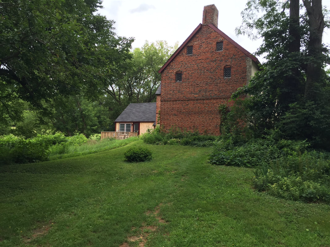 Above: Peasley Garrison House, East Haverhill, Built 1675 (now a private residence). Photo by the author. Similar garrison houses were erected on the periphery of Andover. Religious changes were evident too, causing further strain. The first two generations of New England puritans had been staunch believers, ready to sign up to covenants with their local puritan Meetinghouse vowing pure and virtuous life. Calling the churches “meetinghouses” signified the complete merger of religious life with civic life; all local governance took place within its walls. The right to vote in the local community was tied to membership in the church, which was limited to the elect who had undergone conversion by faith. But by the third generation, in the 1660s, there was a crisis. Were the grandchildren of the puritans who made the perilous journey to the new world presumed true believers? Or did they need to undergo their own personal “conversion”? A compromise was reached – they could sign up for a “half-way covenant”, in which, despite lacking a conversion experience, they could attend worship, but not receive rights to vote. This was the beginning of separation of local church and local government. By the 1690s, we were on the fourth generation, and church membership was plummeting… along with control of mores in the community, said the ministers. Yes, heresies in Boston had been dealt with, such as the expulsion of the Baptist Roger Williams to Providence plantation in 1636, the expulsion of Anne Hutchinson to New York in 1642 and the hanging of Quakers in Boston in the 1660s. However, apathy and alienation were harder to combat than zealous heresy. This was the context of the Salem witch trials. In addition to being the result of social strain wrought by King William’s War, the expansion of witch hysteria arguably represented an attempt by puritan leaders to use the situation to impose moral judgment. Sentences in the witch trials were handed down by William Stoughton, former puritan minister turned politician, who allowed most of the cases to be heard on the basis of spectral evidence: claims by witnesses of supernatural sensations. The court, after handing down its first execution in June 1692, adjourned to obtain advice of leading puritan ministers, who rallied behind the court’s purpose. The primary point of advice of the minsters was for the court to bring utmost help to those suffering molestations from the invisible world, by “speedy and vigorous prosecution of such as have rendered themselves obnoxious.” Below: William Stoughton, the Hanging Judge of the Salem Witch Trials, sitting in front of Harvard College, the seat of learning for the puritan ministry (Source: Wikipedia) 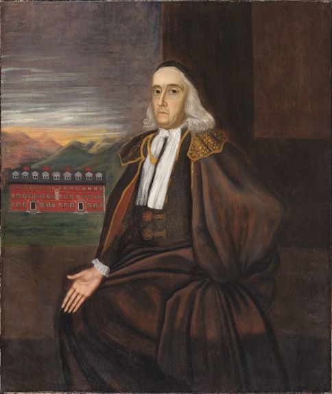 Witches in the family John Ayer, the paterfamilias of all the Ayers in Haverhill and surrounding towns and my tenth great grandfather, passed from this mortal plane in 1657, in Haverhill. He left at least seven surviving children. His wife Hannah lived until 1688, dying at a ripe old age. By some accounts she was more than a hundred when she passed. John Ayer’s inventory upon death included “fower [four] cows, two steers, and a calf; twenty swine and fower pigs; fower oxen; one plough, two pair plough irons, one harrow, one yolke and chayne, and a rope cart; two howes, two axes, two shovels, one spade, two wedges, two betell rings, two sickels and a reap hook hangers in the chimneys, tongs and pot hooks; two pots, three kettles, one skillet, and frying pan in pewter; three flocks, beds, and bed clothes; twelve yards of cotton cloth, cotton wool, hemp and flax; two wheels, three chests, and a cupboard; ‘wooden stuff belonging to the house’; two muskets and ‘all that belong to them’; some books; some meat [presumably cured] about ‘fo[t]rie bushells of corne’; his wearing apparill; about six or seven acres of grain in and upon the ground; the dwelling house and barne and land broken and unbroken with all appurtenances forks, rakes, and other small implements about the house and barne.” Thus, he prospered in the new world. Their son Robert, my ninth great grandfather, was designated a freeman in 1666, made a selectman in 1685, and was known as sergeant of the local militia after 1692. He was even more prosperous than his father, whereas the refugees and other newcomers had virtually no possessions, eking out existences as boarders and field workers. Witchcraft came to the Ayer family when Robert’s sister, Mary Ayer Parker, of Andover, was accused of witchcraft in early September 1692, six months into the witch craze. She was hanged by the end of that month, proclaiming her innocence until her death. Mary had been married to Nathan Parker, a former indentured servant who had settled in Newbury with his brother Joseph sometime in the 1630s. By 1648, Nathan had bought his freedom and was living in Andover, as one of its first settlers. His first wife died, and within a few months he married Mary Ayer. The original size of Nathan Parker’s house lot was four acres but his landholdings improved significantly over the years to 213.5 acres. His brother Joseph, a founding member of the meetinghouse in Andover parish, possessed even more land than his brother, increasing his wealth as a tanner. By 1660, there were forty household lots in Andover (clustered around what is now North Andover common, the original village of Andover), and no more were created. Subsequent landholders built their homes far afield, near their farms. By 1650, Nathan began serving as a constable in Andover. Nathan and Mary had their first child, John, in 1653. Mary bore four more sons: James in 1655, Robert in 1665, Joseph in 1669 and Peter in 1676. She and Nathan also had four daughters: Mary, born in 1660 (or 1657), Hannah in 1659, Elizabeth in 1663, and Sara in 1670. Her son James died on June 29, 1677, age twenty-two. He was killed in a battle with Indians at Black Point, in what is now Scarborough, Maine, in one of the last skirmishes of King Philips War, along with his cousin John Parker (son of his father’s brother Joseph Parker), who had fought in the Great Swamp campaign in Rhode Island a few years previous. Nathan Parker, husband of Mary Ayer Parker, died in June 1685. He left an estate valued at 463 pounds – more than double the estate of his father-in-law John Ayer – and a third of it went to Mary his wife. It is not known what her lifestyle was like after 1685; however, she was likely living alone as all her children were grown and all the girls were married by this time and living in their own homes. Below: detail of map of Andover [now North Andover common] in 1692 prepared by the North Andover Historical Society. It's not clear which residence would have been Nathan Parker's. 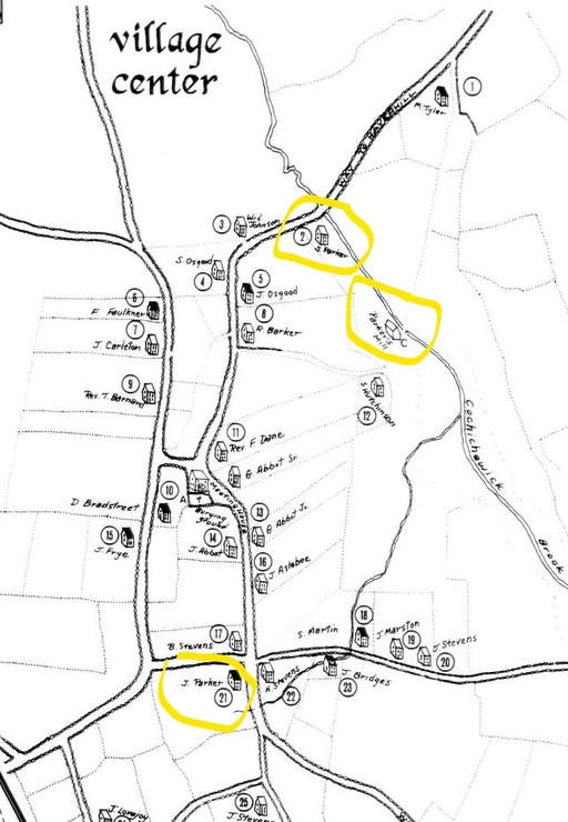 The accusation of witchcraft against Mary Parker She was accused by fourteen-year-old William Barker Jr. in his confession on September 1, 1692. Young William’s father, William Sr., and his thirteen-year-old cousin Mary Barker, daughter of the deacon of the Andover meetinghouse, had already been imprisoned for witchcraft three days earlier. The accused William Jr. stated that he had so recently converted to witchcraft that he “had only been in the snare of the Devil for six days.” He testified that "Goody Parker went with him last Night to Afflict Martha Sprague." Goody was an abbreviation of goodwife, a title used for most married women in puritan Massachusetts. Young William elaborated that Goody Parker "rode upon a pole & was baptized [by Satan] at Five Mile pond." [Now called Haggetts Pond] The examination of Mary Ayer Parker occurred the next day. At the examination, afflicted girls and young women from both Salem and Andover fell into fits when her name was spoken. These witnesses included Mary Warren (a twenty-year-old servant), Sarah Churchill (a refugee from Saco, Maine), Hannah Post (a twenty-six year old whose father Richard had been killed by Indians), Sara Bridges (Hannah Post’s seventeen year old stepsister), and Mercy Wardwell (age nineteen, already under arrest for witchcraft, daughter of wealthy Samuel Wardwell of Andover, who was eventually hanged for witchcraft the same day as Mary Parker). The records state that when Mary came before the justices, these girls and young women were cured of their fits by her touch, which was the satisfactory result of the commonly used "touch test," signifying a witch's guilt. Below: A witness performing the touch test on Giles Corey, accused of witchcraft 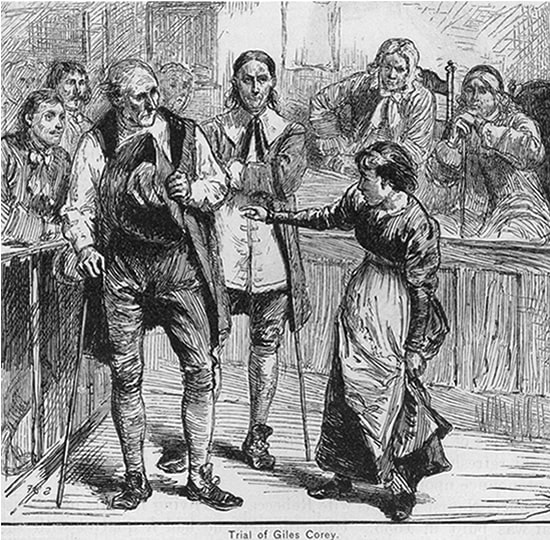 Mary Ayer Parker was tried in Salem. During her examination she was asked, "How long have ye been in the snare of the devil?"
She responded, "I know nothing of it.“ Her defense was mistaken identity: other Mary Parkers lived in Andover – by whom she would have meant either her brother-in-law Joseph Parker’s wife Mary, nee Stevens, or their daughter. It was not clear why she would have tried to throw her relatives ‘under the bus’ (to use an anachronistic phrase). Perhaps there were still hard feelings over the death of her eldest son James after he followed their son John, his first cousin, into war against the Indians. In any case, the court did not buy her defense. Like most accused in the witch trials who protested their innocence rather than confessing being in league with the devil, she was found guilty and hanged. Conclusion Some people think the witch trials were purely the result of the belief systems of the Massachusetts puritans. However, they came into existence at a time of great social stress, as refugees fleeing horrifying Indian raids along the Maine frontier upset the social order of towns like Andover and Salem where they sought shelter. The belief system of the Puritan ministers became a weapon that could be used in a form of class warfare, in which the marginalized could bring down their superiors, especially ones haughty enough not to admit they were in fact witches. Statute in Edson Cemetery, Lowell, Mass. depicting Passaconnaway 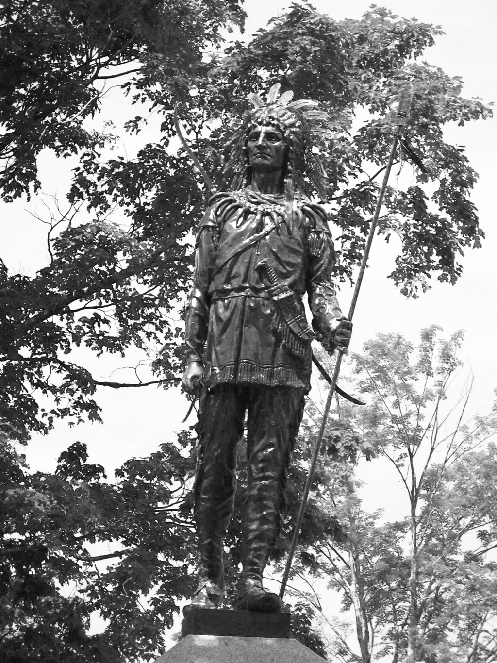 The town of Haverhill was founded by charter of the General Court of Massachusetts in 1640 but title was not transferred until November 15th, 1642, when the great chief of the Pennacooks, the native inhabitants of the entire valley of the Merrimack from Pentucket (later called Haverhill) up to the river’s highest headwaters, transferred twelve miles of land along the river to form Haverhill.
Pasaconnaway had been an impressive leader with magical powers. According to one early English account, “Hee can make water burne, the rocks move, the trees dance, metamorphise himself into a flaming man. Hee Will do more; for in Winter, when there are no green leaves to be got, hee will burne an old one to ashes and putting these into water, produce a new green leaf, which you shall not only see but substantially handle and carrie away; and make a dead snake's skin a living snake, both to be seen, felt, and heard.” Under his leadership, the Pennacooks, whose name aptly means ‘rocky place’ tribe, subsumed the neighboring tribes, the Wachusetts, Agawams, Wamesits, Pequawkets, Pawtuckets, Nashuas, Namaoskeags, Coosaukes, Winnepesaukes, Piscataquas, Winnecowetts, Amariscoggins, Newichewannocks, Sacos, Squamscotts, and Saugusaukes. Alas, the sale of Pentucket (Haverhill) to a group of Englishmen was one of the last historical acts of the Pennacooks. In the devastating war between the English and the natives in 1675– called King Phillip’s War after the Anglo nickname of native leader, Metacom, a Wampanoag from south of Boston – the Pennacooks sought to remain neutral. For safety during the conflict, they largely retreated to their mountain fastness near the headwaters of the Merrimack river high in the White Mountains. The Pennacooks came under suspicion and, upon their return to the lowlands at the end of the war, hundreds of their braves were captured en masse in a treacherous maneuver orchestrated by Captain Richard Waldron. This occurred at the Indian trading post in Dover, New Hampshire, known by the natives as Cocheco. Some of the Pennacook men were hanged for insurrection and the rest were sold into slavery in Barbados. The few remaining members of the tribe began to abandon Passaconnaway’s leadership. They retreated far to the north, to the mouth of the Saint-François River at its confluence with the St. Lawrence, to the reservation established by the French in Quebec, called Saint Francis in English. Today it is still a reservation, called Odanak, home of four hundred Abenaki with whom the Pennacooks merged. The great king Passaconnaway, a.k.a. Papisseconeway, a.k.a. Saint Aspenquid, died in 1682. The few remaining Pennacook warriors bore his body to the summit of Mount Agamenticus, it was said, and laid him to rest in a rocky cave. The alternative and more compelling story is that he was buried at the summit of Mount Agiocochook, now called Mount Washington, the highest mountain in New England, near the headwaters of the Pemigewasset River, itself the northernmost tributary of the Merrimack. Or his body was not borne there at all; rather he ascended there himself like Jesus Christ, whom many of the Indians had adopted by that time as their great spiritual leader. “There was to be a Council of the Gods in heaven and it was Passaconaway's wish that he might be admitted to the divine Council Fire; so he informed the Great Spirit of his desire. A stout sled was constructed, and out of a flaming cloud, twenty-four gigantic wolves appeared. These were made fast to the sled. Wrapping himself in a bearskin robe, Passaconaway bade adieu to his people, mounted the sled, and, lashing the wolves to their utmost speed, away he flew. Through the forests from Pennacook[modern-day Concord N.H., his royal seat]and over the wide ice-sheet of Lake Winnepesaukee they sped. Reeling and cutting the wolves with his thirty-foot lash, the old Bashaba, once more in his element, screamed in ecstatic joy. Down dales, valleys, over hills and mountains they flew, until, at last, enveloped in a cloud of fire, this ‘mightiest of Pennacooks’ was seen speeding over the rocky shoulders of Mount Washington itself; gaining the summit, with unabated speed he rode up into the clouds and was lost to view―forever!” Charles Edward Beals, Jr., Passaconnaway in the White Mountains, 1916. Thus basically ends the story of the Pennacooks, except for the place names they gave. Mount Passaconaway (4,043 ft.) is named for their leader. Mount Wonalancet (3,200 ft.) is named for his son. The Nanamacomuck Trail is named for his other son. The Kancamagus Highway is named for Passaconnaway’sgrandson, son of Nanamacomuck, who in 1689 led a brief and final Pennacook rebellion against the English. It was mainly fought not by Pennacooks but by “a throng of restless and vengeful Androscoggins.” Their crowning accomplishment was to murder the elderly Captain Waldron, who had sold so many of their kinsmen into slavery four decades earlier. The Pennacooks also left us with the names of most of the various tributaries of the Merrimack River: Contoocook (Near the Pines), Squannacook (Green Place), Suncook (Place of Villages), Piscataquog [or Piscatacook] (Great Deer Place), Souhegan (Waiting and Watching Place), Shawsheen (Serpentine), Quinepoxet (Pebbled Bottom). “The great, numerous, and powerful Pennacooks, where are they? Two hundred years have effaced every vestige of the race; they are rubbed out like a chalk mark on a black-board ; every trace of the blood is obliterated; no scion remains; they have withered as the grass beneath the pavement, and the places that knew them once shall know them no more forever. The few fragile and broken remnants of the race, dispirited, and dimly realizing their ultimate doom, long since turned their backs on old· familiar scenes, on the conqueror, and their faces to the setting sun, where year by year his domain is curtailed, and himself more closely environed, until, at no very distant day, he will be totally and finally obliterated from the face of this broad land, and become as much of a myth or tradition, as the centaur, the mastodon, or the sphinx.” J. W. Meader, The Merrimack River: Its Source And Its Tributaries (1869) His son Wonalancet, his daughter Wenunchus and his grandson Kancamagus have their own interesting stories covered in other blog entries. 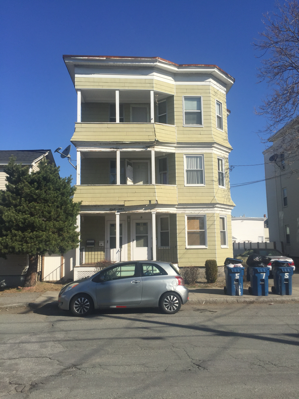 My paternal grandmother Gladys Johnson was born in 1912 at 5 Kingston Street. The structure is pictured above, as of early 2017. Her parents Martin Jonsson (anglicized to Johnson) and Marie Jensen, had come from Hjärsås, Sweden (him) and Gunderup, Aalborg, Denmark (her) around the last decade of the 19th century, first settling in Maine where they first met. Martin worked on the railway all his life, as shown by his retirement announcement in the Lawrence newspapers after many decades (below). His work took him to Concord, N.H. where he married Marie Jensen in 1898. They had their first two children, sons Martin and Roy, in Concord before moving down to Lawrence in 1906. Son Clarence was born in 1910, followed by Gladys in 1912. The family moved around some at first, living at 1 Bailey Street where brother Clarence was born in 1910, then they lived at 5 Kingston Street. By 1920, they were living at 364 Broadway, as shown in the census that year. Son Ray was born 1919. By 1930, they were living at 34 South Street, where my grandmother Gladys lived when she had my father, her oldest, in 1930. Her new husband Clifford McCarthy lived with them until they could get a place of their own, an apartment at 107 Newton Street. Her brother Martin died at 5 Kingston Street, in March 1911, age 9, of Hodgkin’s disease. 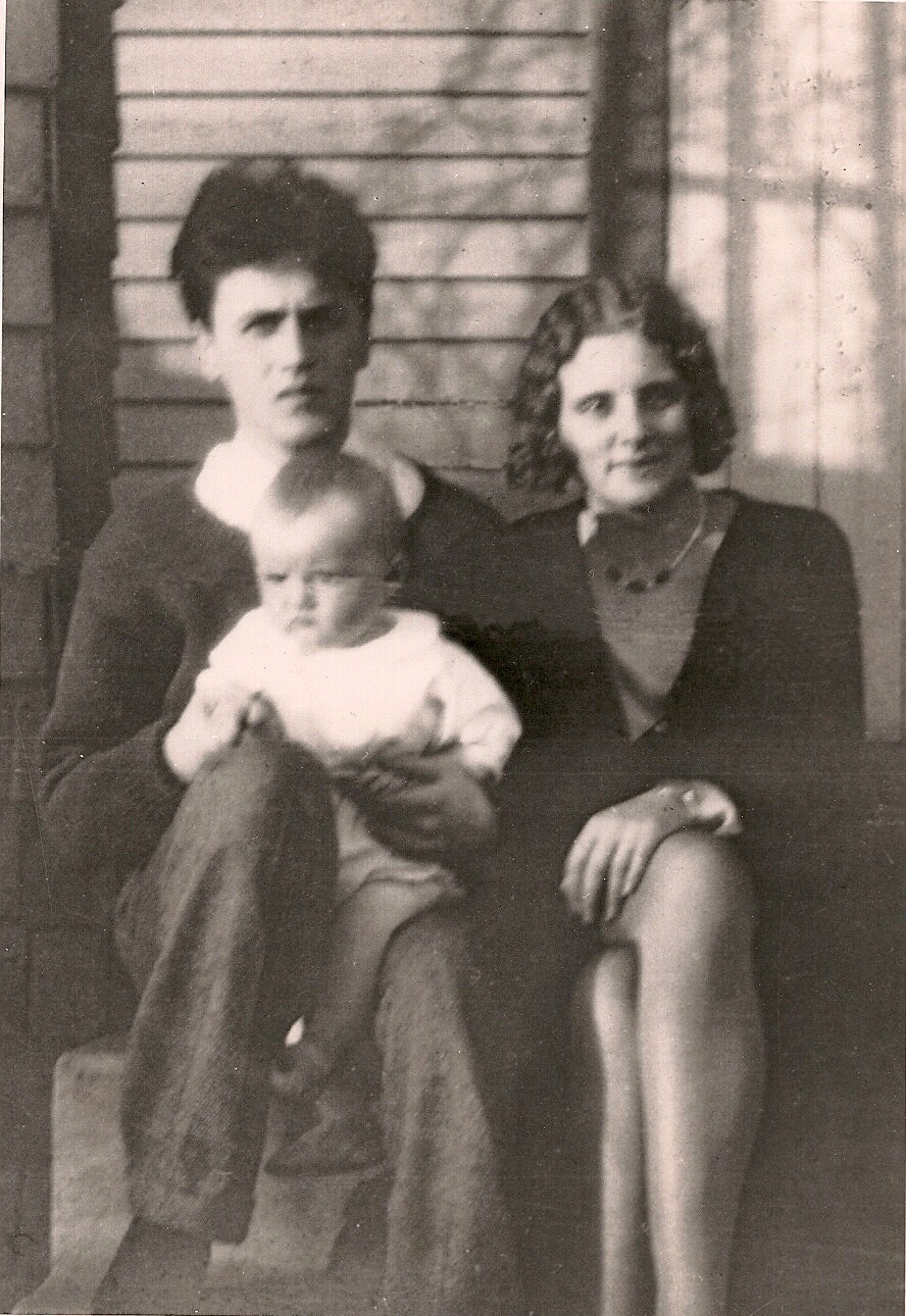 Clifford and Gladys with their son Richard, my father, fall 1930 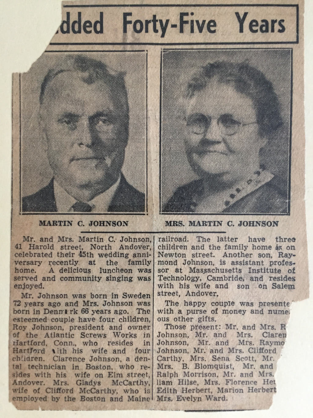 Wedding anniversary announcement of Gladys’s parents Martin and Marie in 1943 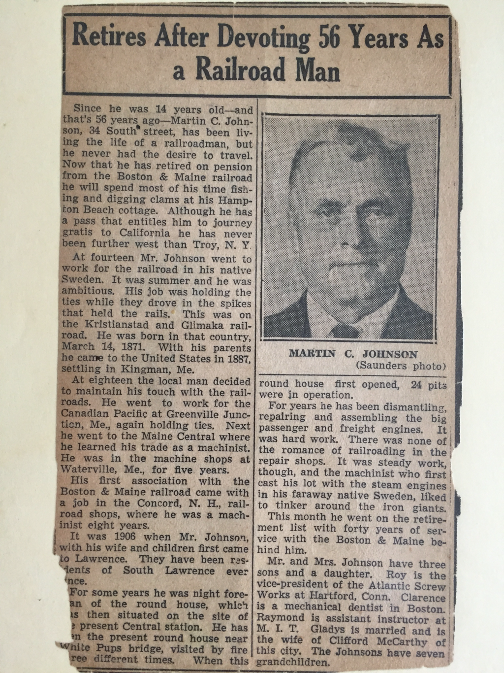 Retirement announcement of my great grandfather Martin Johnson in 1941
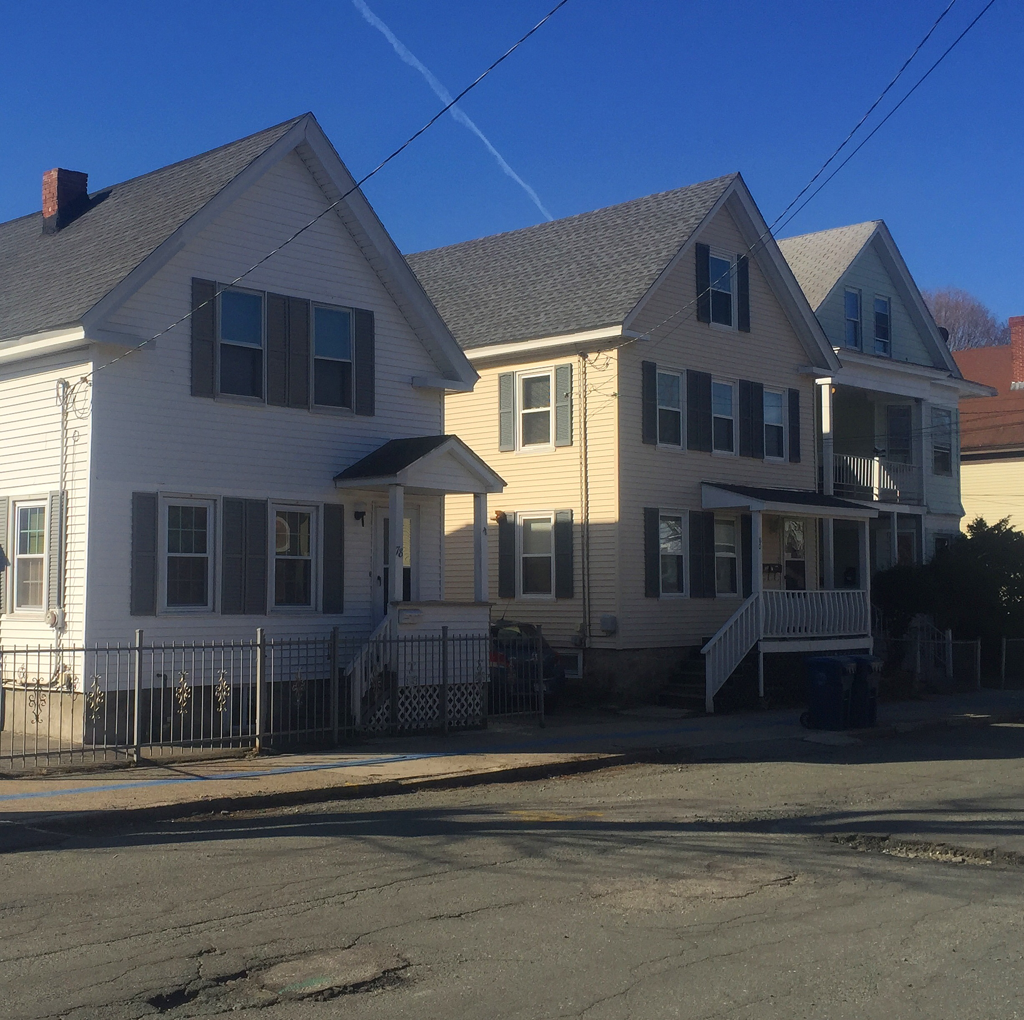 The property that became 78 (far left house) and 80 Kingston Street in South Lawrence was bought by my great grandfather Jeremiah Driscoll in 1867 for $168, when the land was parceled but not yet graded for streets. Jeremiah previously lived in the Irish shantytown of which this site was a part. Eleven relatives either were born or died in these houses over the years. They were sold in 1948 by my grandmother Mary Driscoll McDonnell, who was born at 80 Kingston Street in 1900. Below is an excerpt from the Lawrence city directory in 1864. 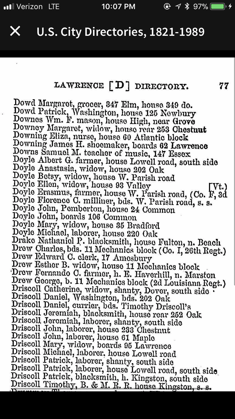 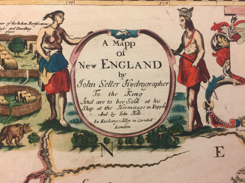 Below is a closeup of the Merrimack Valley section of an amazing map printed in London in 1670. Two cool features: First, it shows “Old Norfolk” County, the old county of Norfolk that extended from the Merrimack River north to the Piscataqua River. It existed from around 1640 to around 1680. Of note, Haverhill and Salisbury, being north of the Merrimack, are in Old Norfolk not Essex County where they later ended up, and so is all of what is now coastal New Hampshire. New Hampshire as a concept didn’t exist yet and Massachusetts Bay Colony asserted jurisdiction. Second, the map shows the Indian “praying town” of Wamesit, in modern-day East Chelmsford. The puritans (naturally) attempted to Christianize the natives. They - led by reverend John Eliot -went through great effort to translate the native Algonquin language into English so they could provide the Indians with a bible, called Mamusse Wunneetupanatamwe Up-Biblum God. They also had to teach the natives to read this new book written in Algonquin, a hitherto oral language. The Algonquin bible is a fascinating topic to which I hope to dedicate future blog entries. I can't decide whether to take it seriously. Some of the translations in generated are so absurd on their face as to call into question the validity of the whole endeavor. For example, Elliot translated "our lusts" (an important word no doubt for the puritans as "Nummatchekodtantamooongannunonash" which cannot possibly be a word. He translated "our loves" as Noowomantammoonkanunonnash, and "our questions" as Kummogokdonattoottammooctiteaongannunnonash, which might be the longest word I have ever seen. Some of the natives who converted were settled in so-called Praying Towns. I will write a separate blog post on the Praying Towns. After the first war between the English colonists and the natives in 1675 (which basically launched fifty years of intermittent Indian attacks on settlements like Haverhill and Andover), the Praying Towns were abandoned. Also a topic for a future blog post. 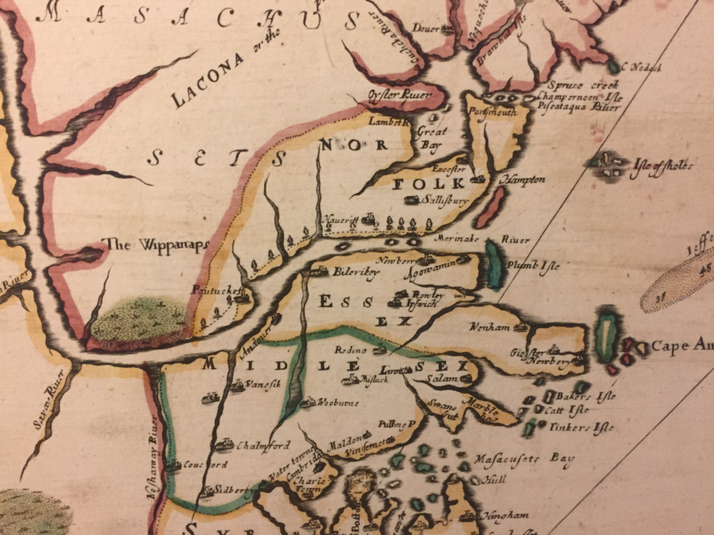 The towns of Andover and Haverhill are visible, along with places like Salisbury downriver and Chemsford upriver. Present-day Lowell is called Pawtucket and present-day Newburyport is called Agawamin (not to be confused with present-day Agawam in Worcester County).
Revised 7-19-18 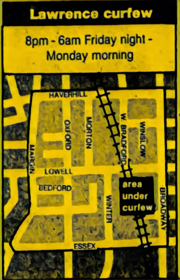 Above: Leaflet showing area under police curfew after the second night of rioting The riot started the night of August 8, 1984 near the intersection of Oxford Street and Haverhill Street, and flared up again the next night. News accounts describe the area of the riot as "Lower Tower Hill", however, it really occurred right below Tower Hill in the flatlands that end at the aptly-named Margin Street. The unrest spread not up the hill (which would be to the left on the map) but along the base of the hill, over to the Merrimack Courts housing projects on Essex Street, and then to the Hancock projects beyond. Below: Coverage of the riots in the Boston Herald 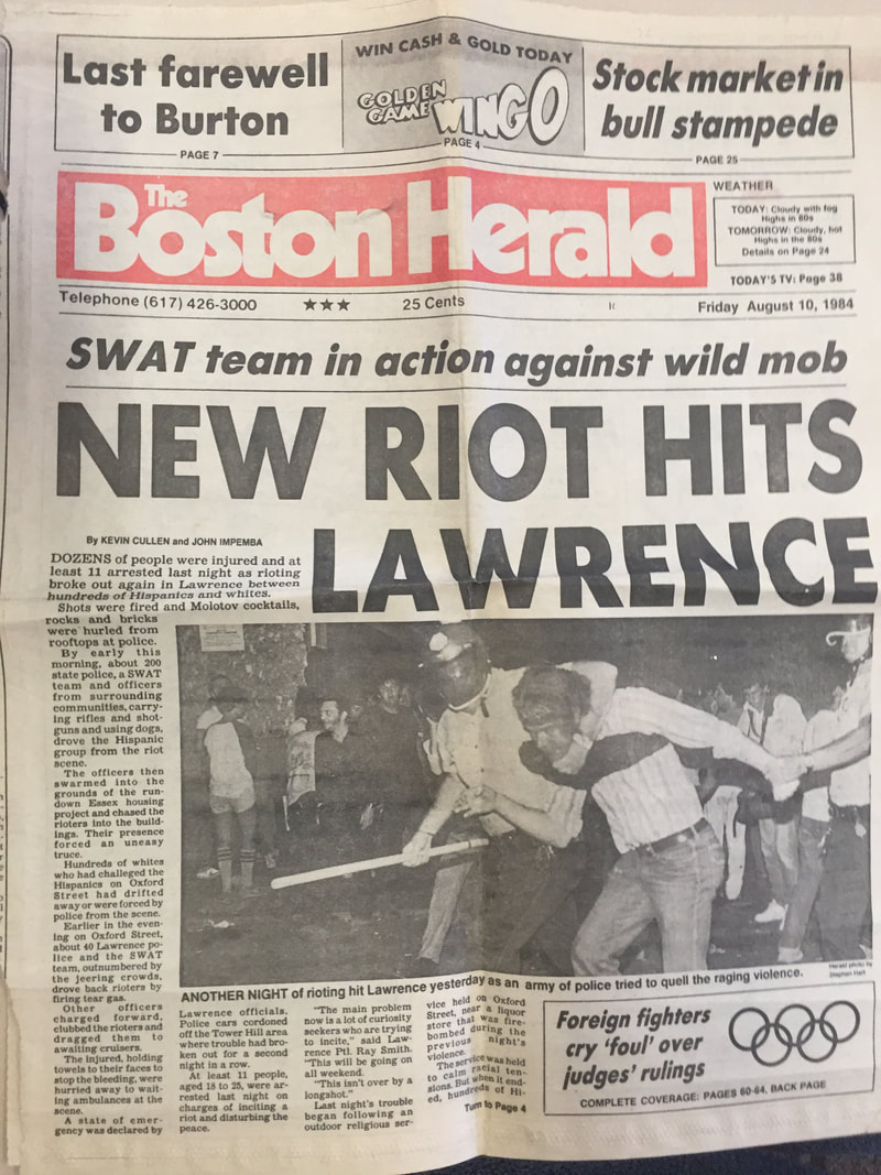 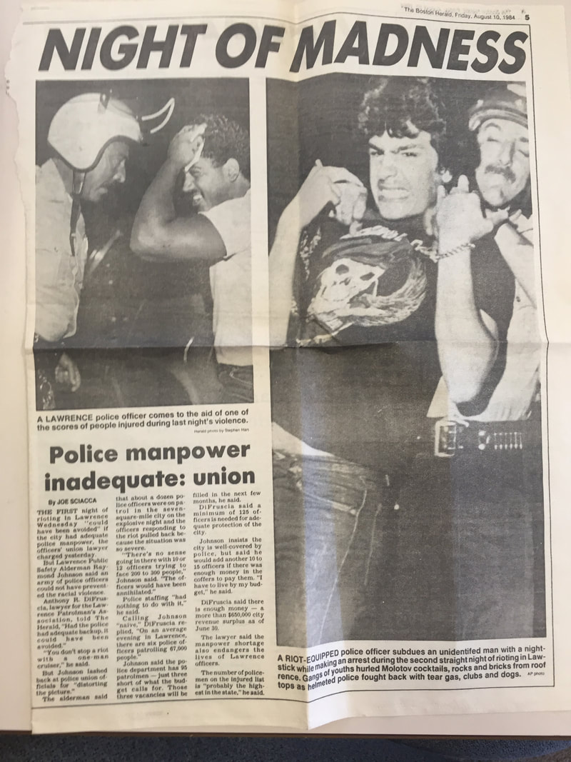 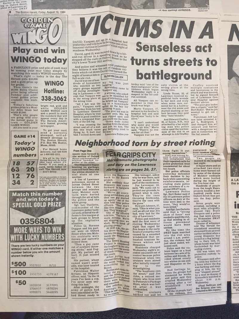 In my view, the riot was not a very big disturbance, albeit one that local police could not get under control on the first night. It happened less than half a mile from my house with no immediate impact beyond a narrow zone running between Broadway and Margin Street along the base of Tower Hill, across an area of probably less than ten acres. I have suggested that it was more like a large-scale rumble, and not a "riot" in the same sense as the gigantic Detroit riots or Watts Riots which ranged over hundreds of acres destroying a lot of those cities. Even locally, compare the 1964 Hampton Beach riot, which involved up to 10,000 youth battling state police from New Hampshire and Maine and many neighboring towns. This riot was more of a local affair. Sometimes the rioters even cooperated, for example when they were dividing the loot: “At 11:00 PM rioters broke into Pettoruto’s liquor store. The Eagle-Tribune reported that at first the two groups [presumably whites and hispanics] fought over the liquor, but then they cooperated to divided it up and share it, after which a ‘lull followed with a lot of public drinking.” This is from Llana Barber's book Latino City, mentioned below. The author notes dryly, “This odd reprieve could not have been long lived, because by 12:15 AM, the liquor store was on fire.” A theory about the riot: I have a theory that the riot was directly related to the 1982 "desegregation" of the two nearby schools, which destabilized the geographic social order by giving kids from the "wrong" side of an invisible line a newfound right to pass all the way to the top of the hill, which at that time was another world. The two schools involved were the Hennessy School down on Hancock Street next to the projects; and the Bruce School (my school from kindergarten through 8th grade), at the top of the hill. School desegregation upset longstanding geographic hierarchies of the area, which were based as much on social class as ethnicity or race. When I was a kid, in the single family homes and duplexes near the Reservoir or up the hill from the Bruce, families were "middle class". The parents of about half my neighbors were college educated, many of them teachers or working for the city; and the other half owned small businesses, such as plate glass or oil delivery, or sold insurance, or did other respectable, responsible things. Nearly everyone owned their home. Going further down the hill, the homes were multifamily and the youth were often rougher. Nobody went to college. Almost everyone rented. Dads seemed to be in motorcycle gangs, fixed cars, worked as roofers. Down at the bottom, where the slope ended and the terrain flattened out, were fresh-off-the-boat immigrants...most recently from the Dominican as well as Puerto Ricans who had started arriving in the early 1970s. After the 1982 desegregation, the population of the Bruce School changed dramatically. In a short while, many of my friends switched schools. The nearby parochial school on Ames Street, St. Augustine's, had a couple banner years of attendance (it is now closed). The Bruce school was to be flooded with kids from down the hill. To entice some middle class families to stay, a "Magnet School" was created in a neighboring building, a former synagogue that had relocated to Andover when the congregation all moved away in the 1970s and early 1980s. (The J.C.C. fifty yards from my house limped on, without members, before finally closing in 1990.) Despite the magnet school and the availability of St. Augustine's parochial school, the neighborhood also changed character within a couple years. The population from down the hill came up the hill, as the previous population moved out, so that the line that used to be at Margin Street moved up the hill a few blocks every year. Eventually, everything had changed, all the way over the top of Tower Hill and down the backside of the hill to Methuen. In 1985, the Hispanic population of Lawrence was 16%; it is presently around 80%, in a city that has 15,000 more residents than it did back then. I'm sure my former neighborhood is also 80% Hispanic overall. My parents still live there, up by the Reservoir. Professor Llana Barber extensively discusses the Riot in her book Latino City (2017), giving a synopsis of how Lawrence became a Latino city through and through. My review of her book is here. The poorly executed 1982 school desegregation that conflated race and ethnicity with social class, and then the riot, simple hastened a trend that would have happened anyway: Lawrence becoming a majority-minority city. In many ways, Lawrence is now a Hispanic Shangri-La, a place where people of a shared culture can live among their own, while still participating in the overall economic benefits of the Greater Boston area. The people who have moved out of Lawrence since the 1980s often look back with nostalgia on the way things used to be, and some of them unfairly scapegoat the new immigrants of Lawrence for what they see as negative change. However, I'm sure that in 30 years, when the current residents of Lawrence and their kids have also moved on, to "better" areas, they too will look back fondly on the old neighborhood in Lawrence where everyone spoke their language, listened to their music, and ate their cuisine. Below: AP photo of riot police in Lawrence. Erika Market was on the corner of Oxford Street and Lowell Street. 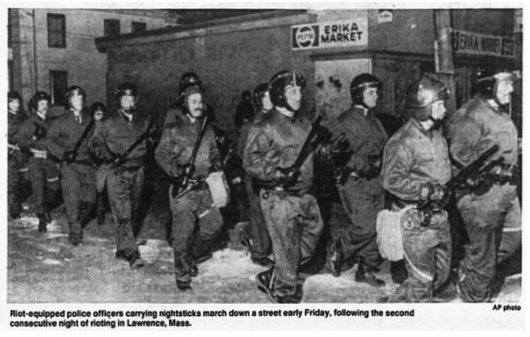
I have not been able to determine where any Irish ancestors lived before they emigrated to the United States at the time of the Potato Famine. The most I have been able to find is ports of disembarkation via ship records.
A huge drawback in doing research is that the Irish census records for the years 1821 to 1851 were almost entirely destroyed in the fire which consumed the Public Record Office of Ireland in 1922 after bombardment in the Irish civil war. The 1821 census was the first full census of Ireland. Nationwide civil registration of births and deaths started in 1864, and is therefore also not helpful. “Before the start of civil registration for all in 1864, virtually the only direct sources of family information for the vast majority of the population are the local parish records. However, because of the disadvantages suffered by the Catholic Church from the sixteenth to the nineteenth centuries, record-keeping was understandably difficult…”[1] “In the poorest and most densely populated rural parishes of the West and North, those which saw most emigration [most ancestors named Driscoll, McDonnell as well as McCarthy would have likely come from the far southwest], the parish registers very often do not start until the mid or late nineteenth century. However, the majority of Catholic registers begin in the first decades of the nineteenth century, and even in poor areas, records were often kept from an earlier date.” Unfortunately, many Catholic parish records are not online. “The only way to be sure of the extent of surviving records is to check the individual parish. The National Library catalogue, available at the counter in the main reading room [of the Irish National Records Office], is the only printed, comprehensive, country-wide account of Catholic registers…” That said, an increasing number of Catholic church records have been put on line starting in 2011, although not everything has been indexed. www.irishgenealogy.ie/en/church-records/help/searching-by-person Even if I find the time someday to investigate Catholic parish records in detail, deciphering them might not be easy. “Baptisms and marriages are recorded in either Latin or English, never in Irish. Generally, parishes in the more prosperous areas, where English was more common, tended to use English, while in Irish-speaking parishes Latin was used.” Assuming most of my ancestors came from rural Cork, Irish (or Gaelic) would still have been used in some pockets. The fact that names are in Latin presents research problems. Here is a partial interpretive key showing how English names were translated into Latin. (Keeping in mind that most English names were Anglicizations of traditional Gaelic names!): Carolus = Charles Demetrius = Jeremiah/Jerome/Dermot Gulielmus =William (I have not seen any William among my Irish ancestors) Eugenius = Owen or Eugene Jacobus =James Ioannes or Joannes = John; and so on. Dispensations for marriages between cousins were often given. “These were necessary when the two people marrying were related, consanguinati, and the relationship was given in terms of degrees, with siblings first degree, first cousins second degree, and second cousins third degree, Thus a couple recorded as consanguinati in tertio grado are second cousins, information which can be of value in disentangling earlier generations.” A typical Latin entry in its full form might read: Baptisavi Johannem, filium legitimum Michaeli Sheehan et Mariae Sullivan de Lisquill. Sponsoribus, Danielus Quirk, Johanna Donoghue. Much more often the entry is abbreviated to: Bapt. Johannem, f.l. Michaeli Sheehan et Mariae Sullivan, Lisquill, Sp: Daniel Quirk, Johanna Donoghue. Translated, this is simply "I baptised John, legitimate son of Michael Sheehan and Mary Sullivan of Lisquill, with godparents Daniel Quirk and Johanna Donoghue". A typical Latin entry for a marriage would read: In matrimonium coniunxi Danielum McCarthy et Brigidam Kelliher, de Ballyboher. Testimonii: Cornelius Buckley, Margarita Hennessy. Abbreviated, the entry reads: Mat. con. Danielum McCarthy et Brigidam Kelliher, Ballyboher. Test. Cornelius Buckley, Margarita Hennessy. Meaning, simply, "I joined Daniel McCarthy and Brigid Kelliher, of Ballyboher, in matrimony; witnesses, Cornelius Buckley, Margaret Hennessy." The fact that Irish children were typically named after specific relatives in accordance with birth order, most families have a limited set of first names, making research more difficult because many people have the same first and last name! Irish naming conventions - or why everyone in an extended family seems to have the same five or six names! The common practice of naming children after relatives according to a set formula meant that families often had a constellation of a dozen or fewer first names for girls and a dozen or fewer first names for girls across many generations, especially if cousins were marrying each other. The first born daughter is named after the maternal grandmother (mother’s mother); first born son is named after the paternal grandfather (father’s father); the second daughter is named after the paternal grandmother (father’s mother); the second son is named after the maternal grandfather (mother’s father); the third daughter is named after the mother; the third son is named after the father; the fourth daughter is named after her mother’s oldest sister (Aunt), the fourth son is named after his father’s oldest brother, etc. Among my Driscoll ancestors (my mother's mother's maiden name), the main names include John, Patrick and Jeremiah for boys, and Mary and Ellen for girls. Jeremiah somehow had become the Anglicization of Irish name Diarmaid, now more commonly anglicized as Dermot. [1] http://www.irishtimes.com/ancestor/browse/records/church/catholic/#Church. All text in quotes in this blog entry comes from this source. My research on Native American interactions with early English settlers of Massachusetts and New England led me to the writings of one Thomas Morton, who in 1638 wrote detailed accounts of the Pennacook and other bands of Indians. (Note - I tend to call the colonists “English” and the natives “Indians” because all the writings from the colonial period use these terms.)
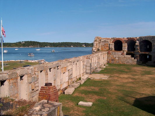
It turns out that, in 1626, before the Puritans were establishing Boston, Thomas Morton and some friends established a colony called Merrymount (as in, a hill for merriment), a.k.a. Wallaston. The name lives on as a subway stop on the Red Line in Quincy, Mass., site of the small colony, but it otherwise seems to have been forgotten. From what I could gather, it was sort of the anti-Puritan colony, full of drunken revelry, hooking up with native females, and a lot of other activity that no doubt drove the puritans mad. Here are some of my quick notes. Some of this might be cut and pasted from copyrighted material so I may need to edit this. Morton disdained the Pilgrims at Plymouth, who he called ‘those Moles.’ He complained they ‘keep ‘much ado about the tithe of mint and cumin, troubling their brains more than reason would require about things that are indifferent.’ He called the first governor of Massachusetts, John Endicott, “that great swelling fellow, Captain Littleworth,” and called the short Myles Standish, military leader of the Plymouth colony, ‘Captain Shrimpe.’ On May 1, 1627, Merrymount decided to throw a party in the manner of Merrie Olde England. Morton hoped it would attract some Indian brides for his bachelor followers. Thus, he violated a cardinal concept of English settlement of New England: endogamy, or marriage solely within the group. In contrast to French Quebec and Acadia, where European-native marriages were tolerated (possibly because settlement was largely by men), they were a big no-no in New England (possibly because settlement was by supposed to be by families and entire villages that came over from England together). Morton was arrested on Sept 30, 1629 and was sent back to England by the Puritan authorities. The account of his transgressions said, "The inhabitants of Merrymount ... did devise amongst themselves to have ... Revels, and merriment after the old English custom ... & therefore brewed a barrell of excellent beer, & provided a case of bottles to be spent, with other good cheer, for all comers of that day. And upon Mayday they brought the Maypole to the place appointed, with drums, guns, pistols, and other fitting instruments, for that purpose; and there erected it with the help of Savages, that came thither of purpose to see the manner of our Revels. A goodly pine tree of 80 foot long, was reared up, with a pair of buckshorns nailed on, somewhat near unto the top of it; where it stood as a fair sea mark for directions, how to find out the way to mine Host of Ma-re Mount." Gov. William Bradford was horrified by the ‘beastly practices of ye mad Bacchanalians.’ After a second Maypole party the next year, Myles Standish led a party of armed men to Merrymount, seized Morton and put him in chains. Not a shot was fired. According to Morton, the Merrymount inhabitants didn’t want bloodshed. According to Bradford, they were too drunk to resist. Morton wrote a guidebook of sorts in 1638 while back in London, on the culture of the New England Indians. He supposedly used the money from the sale of the book to pursue a lawsuit against the Massachusetts Bay Colony. I don’t know what came of that lawsuit. In his book, he compares the native Americans to the Irish in their primitiveness. “The Natives of New England are accustomed to build themselves houses much like the wild Irish; they gather poles in the woods and put the great end of them in the ground, placing them in form of a circle or circumference, and, bending the tops of them in form of an arch, they bind them together with the bark of walnut trees, which is wondrous tough, so that they make the same round on the top for the smoke of their fire to ascend and pass through; these they cover with mats.” He also wrote, “when they have their apparel on they look like Irish”. Ireland was of course England’s first colony. 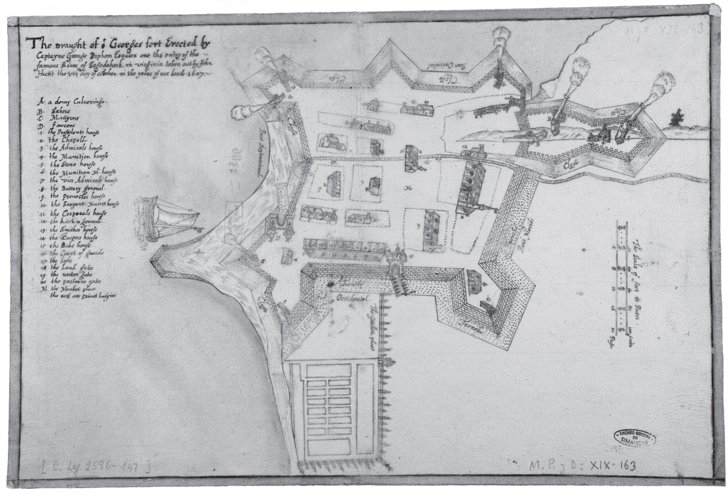 The "Hunt Map" showing Fort St. George, the fortification at the short-lived Popham Colony Everyone knows the story of the Plymouth Colony of 1620, revisited every Thanksgiving, and many people have at least some notion of the Puritan settlement of Massachusetts Bay Colony. However the English colonization of New England was sometimes a messy affair full of false starts and paper claims, especially to the north of Massachusetts Bay. The story of New Hampshire (which managed to break away from Massachusetts for good in 1741) and Maine (which took until 1820) can be covered in other blog entries. Here are some notes on the short-lived Popham Colony of 1607. Until this year I had never heard of it. The Popham Colony—also known as the Sagadahoc Colony—was a short-lived English colonial settlement in North America that was founded in 1607 and located in the present-day town of Phippsburg, Maine, near the mouth of the Kennebec River by the proprietary Virginia Company of Plymouth. It was abandoned after a year despite low mortality. The first ship built by the English in the New World was completed during the year of the Popham Colony and was sailed back across the Atlantic Ocean to England. The pinnace, named Virginia of Sagadahoc, was apparently quite seaworthy, and crossed the Atlantic again successfully in 1609 as part of Sir Christopher Newport's nine vessel Third Supply mission to Jamestown. Postage Stamp from 1957 Commemorating the "Virginia of Sagadahock" 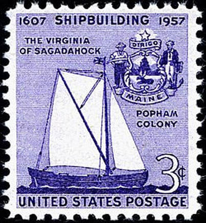 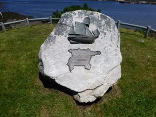 A contemporary monument to the ship Virginia of Sanghedoc at the Popham site On May 31st, 1607, the ships Gift of God and Mary and John departed for the intended Popham Colony carrying some 120 colonists - a slightly larger group than had travelled from London to Jamestown. Unlike that rival expedition, the Plymouth group took just nine council members and half-a-dozen other notable gentlemen, with the majority being mainly soldiers, craftsmen, farmers and traders, their objective to reach the coast of 'North Virginia' at a latitude of about 43 degrees north. The Gift of God arrived at the mouth of the Sagadahoc River (now the Kennebec in Maine) on August 13th, and Mary and John followed three days later. • The exact site of Popham Colony was unknown in modern times until it was discovered in 1994 and excavated by archaeologists for next ten years. It was within a stone's throw of present day Fort Popham, built during the U.S. Civil War to protect the mouth of the Kennebeck. • Discovery was aided by the picture-plan of Fort St. George that was drawn on site by one of the colonists. It is unique since it is the only detailed drawing that exists for an initial English settlement anywhere in the Americas. Fortified with a ditch and rampart, the enclosure contained a storehouse, chapel, guardhouse, and other public buildings, as well as residences for the colonists. The fort was defended by nine guns that range in size from demi-culverin to falcon. The boat built by the colonists, the pinnace Virginia, floats offshore although it could not have been completed by the date of the map. • The Hunt map had been lost to history until it surfaced in a royal archive in Simancas, Spain in 1888. It ended up there via a 1608 dispatch to the Spanish king from Don Pedro de Zuniga the Spanish ambassador in London. The dispatch also contained a sketch of the English colony at Jamestown also founded in 1607. How he got his hands on hunt’s map is unclear. • The 1607 founding of the Popham Colony (also called Fort George) was the second attempt by the Plymouth England branch of the Virginia Company which had been given a charter to coastal North America above the 38th parallel, roughly modern northern Virginia. The more famous Virginia Company of London was given a charter south of the 41st parallel (roughly modern NYC). Note the geographic overlap. • The Richard, a ship sent by the Plymouth Company in August 1606 under the command of Captain Henry Challons, never reached its intended destination in what is now the state of Maine, being intercepted and captured by Spanish forces near Florida in November 1606. • The Popham Colony was abandoned because leader George Popham died (his rich uncle had financed the expedition), and second-in-command Robert Gilbert learned he had inherited a title and landholdings back in England. Below: Map Showing the lands granted to the two Virginia Companies, the more famous Virginia Company of London (founders of Jamestown) and the Virginia Company of Plymouth (founders of the unsuccessful Popham Colony - later, they took jurisdiction over the Separatist colony that incidentally landed in their claim, which was named Plymouth). Note the overlapping area between the two companies. SOURCE: www.mainestory.info/maine-stories/popham-colony.html (Pat Higgins) 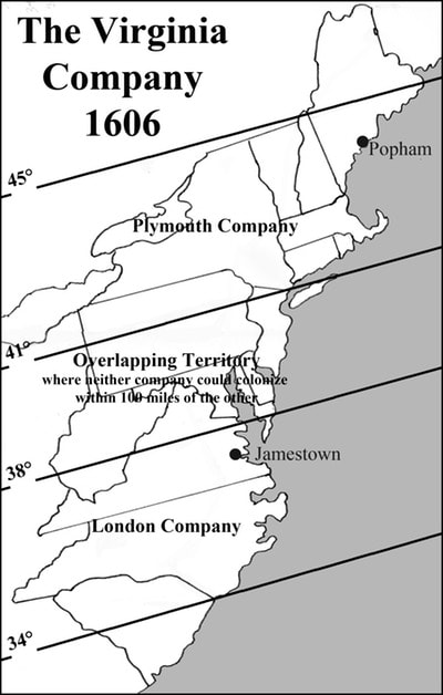 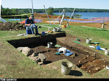
 |
|
|||||||||
 RSS Feed